
Virtual Nature Center

View from Clow Ridge looking upstream toward Boonville
This annotated webliography provides links to many of the information sources about natural and cultural resources and their management in the Navarro River Watershed and Anderson Valley. Included are publications that may be downloaded and links to web sites of interest. This is a living list in that it will be amended as new sites are discovered.
THE RIVER
Current and Historic River Flows: The California Department of Water Resources provides information at 15 minute intervals on stream flows in the Navarro River. Go to this web page and enter the code under Station ID: NRN
http://cdec.water.ca.gov/dynamicapp/QueryF?s=
The National Oceanic and Atmospheric Administration and National Weather Service site provides current river stage and flow information. Data is available for the current hour, as well as the past 1, 2, and 3 hours.
https://www.cnrfc.noaa.gov/graphicalRVF.php?id=NVRC1
The United States Geological Survey site provides current river stage and flow information. Data is available for the current hour, as well as the past 1, 2, and 3 hours.
https://waterdata.usgs.gov/nwis/uv/?site_no=11468000&PARAmeter_cd=00065,00060,00062,72020
THE WATERSHED
What is the Watershed?: An introduction developed by the Navarro-by-the-Sea Center for Riparian and Estuarine Research of the Navarro River Watershed, the largest coastal basin in Mendocino County.

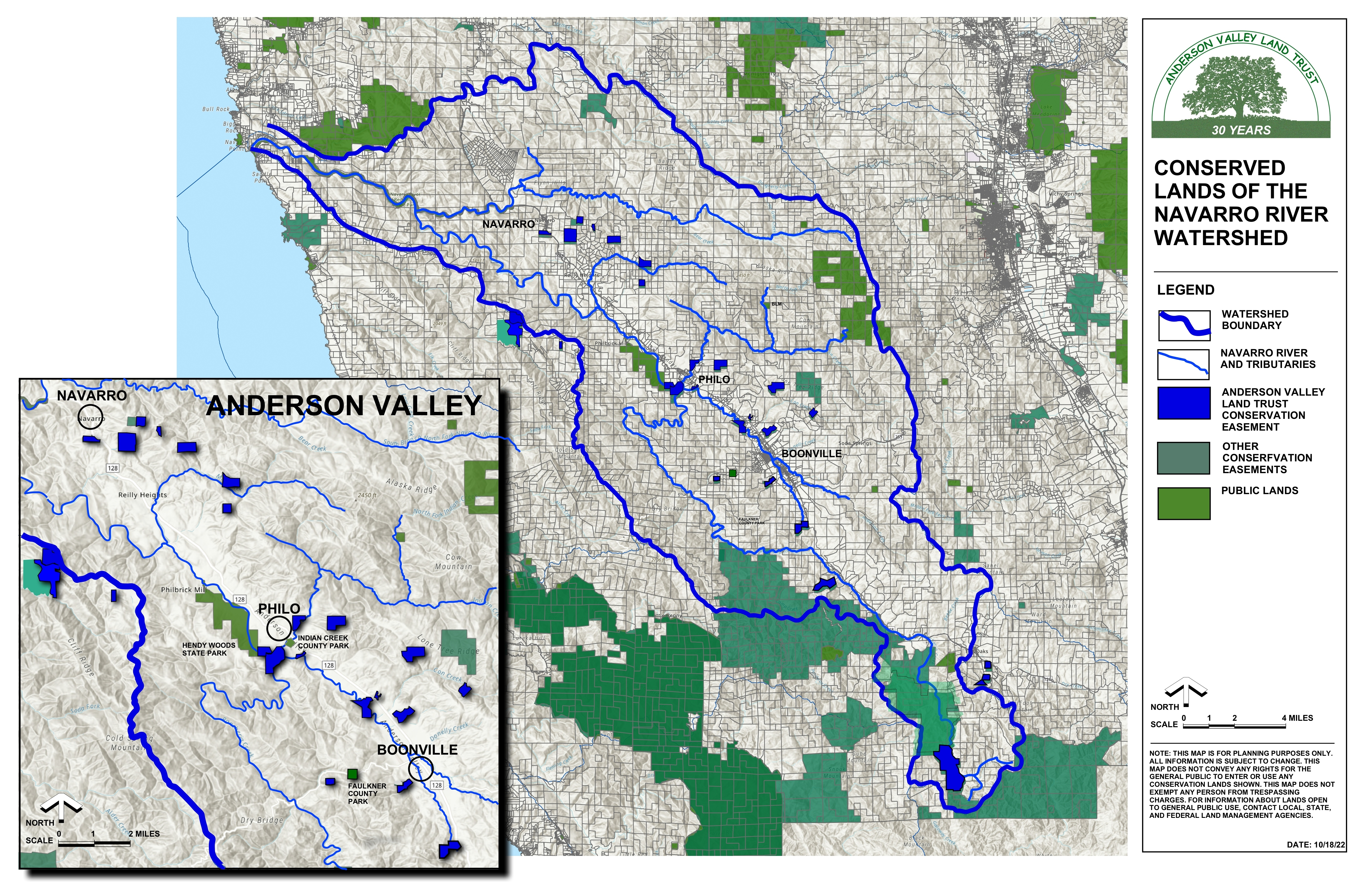
Click here to download full size image
Navarro River Resource Center: Offers outreach, education and technical information resources to the local community and general public in the interest of furthering restoration in the Navarro River watershed.
https://www.facebook.com/Navarro-River-Resource-Center-181835965222513/
Navarro Watershed Restoration Plan: Published in 1998 by the Anderson Valley Land Trust, California State Coastal Conservancy, and The Mendocino Water Agency, this landmark plan overviews limiting factors to salmon production and land use-related impacts to water quality and provides a strategic analysis of the sub-basins and stream reaches where restoration and enhancement actions can have the greatest benefit. Background studies for the Plan include hydrology, geomorphology, sediment production, salmonid habitat condition and distribution, stream flow, stream temperature, water quality, land use patterns, and impacts of the major historical and current land uses. Based on these studies, the Plan makes recommendations for voluntary restoration and conservation actions to benefit water quality in general and the salmon fishery in particular.
http://www.krisweb.com/biblio/navarro_mcwa_entrix_1998_restplan.pdf
North Coast Regional Water Quality Control Board - Navarro River TMDL: A site with technical reports and maps about the Navarro River watershed and the Total Maximum Daily Load (TMDL) Implementation Policy for Sediment Impaired Receiving Waters in the North Coast Region, adopted by the North Coast Regional Water Quality Control Board in November 2004.
https://www.waterboards.ca.gov/northcoast/water_issues/programs/tmdls/navarro_river/
Meeting Irrigated Agriculture Water Needs in the Navarro River Watershed: A site about the water use and needs within the watershed, the efficiency of irrigation practices, and an estimate of available land for agricultural expansion in the watershed.
https://ucanr.edu/sites/Mendocino/files/168821.pdf
Navarro River Total Maximum Daily Loads for Temperature and Sediment: A report prepared in 2000 by the U.S. Environmental Protection Agency to identify temperature and sediment loading allocations at levels that are necessary to implement water quality standards for temperature and sediment for the Navarro River and its tributaries.
http://www.krisweb.comwww.krisweb.com/biblio/navarro_usepa_regionix_2000_tmdl.pdf
Navarro River Watershed Bibliography: An extensive list and link to publications, reports, and memos from 1972 to 2001 about the Navarro River Basin developed by the KRIS Navarro project and funded by the Sonoma County Water Agency (SCWA) and overseen by the North Coast Regional Water Quality Control Board (NCRWQCB).
http://www.krisweb.com/biblio/biblio_navarro.htm
Navarro River Basin Pilot Project: A report by The Nature Conservancy with the Mendocino County Resource Conservation District on the total area of irrigated vineyards and their relationship to alternative water management strategies that would improve flows for fish in critical habitat reaches, while preserving or enhancing the water security of vineyard landowners.
https://mn-ucsb-1.dataone.org/knb/d1/mn/v2/object/karakoenig.56.1
Evidence of Ecologically Relevant Degradation of Summer Base-flows in the Navarro River, California: A 2012 UC Berkeley term project about water flows and water demand for agriculture.
https://www.researchgate.net/publication/312310752_The_impact_of_abiotic_and_biotic_stressors_on_salmonids_in_the_Navarro_River_watershed_Vols_I-III
Mendocino Redwood Company (MRC)
Management Plan: This document includes not only the goals and targets for forest management by the Mendocino Redwood Company, it includes lists and maps of the natural resources within, among others, the Navarro River watershed.
https://www.hrcllc.com/sites/default/files/inline-files/MP_Rev007.pdf
Habitat Conservation Planning:
A series of draft documents prepared in 2012 by MRC describing management alternatives for 213,000 acres of its ownership that includes lands within the Navarro River Watershed. The documents were prepared in support of an 80-year authorization to take certain protected species incidental to MRC’s forest land management activities. They include:
• Draft Environmental Impact Statement/Program, Timberland Environmental Impact Report for Authorization of Incidental Take and Implementation of the Mendocino Redwood Company Habitat Conservation Plan / Natural Community Conservation Plan and Timber Management Plan: https://www.fws.gov/gisdownloads/R8/Arcata_FWO/MRC_HCP/Draft%20EIS-PTEIR%20for%20MRC%20HCP-NCCP%20and%20TMP.pdf
PLANTS AND WILDLIFE
Protecting Salmon and Steelhead in the Navarro River - Water Solutions for Vintners and Salmon in the Anderson Valley: The story of The Nature Conservancy collaborating with water users, from residential landowners to vineyards, to better manage water diversion in the watershed to create win-win water-use strategies that don’t leave salmon and steelhead behind.
https://www.nature.org/en-us/about-us/where-we-work/united-states/california/stories-in-california/salmon-wine-water/
The Future of Coho Salmon / Navarro River Hypotheses: A web site that outlines 5 hypotheses for the future of coho salmon in the Navarro River basin based on variations of high water temperature, reduced supply of large wood, high sediment yields, and reduction of surface flows in the river.
Hypothesis #1: The distribution and abundance of coho salmon in the Navarro River basin has diminished over recent decades.
Hypothesis #2: Coho salmon production is limited by high water temperature in some reaches of the Navarro River.
Hypothesis #3: A reduced supply of large wood has contributed to the loss of pool habitat and the decline of coho salmon in the Navarro River basin.
Hypothesis #4: High sediment yield in Navarro River basin has caused aquatic habitat changes which limit coho salmon and steelhead production.
Hypothesis #5: Surface flows in the Navarro River basin have been diminished in recent decades, which reduces salmon and steelhead productivity.
An Integrated Approach to the Discrimination of Riparian Vegetation in the Navarro River Watershed: A classification of riparian vegetation.
https://aviris.jpl.nasa.gov/proceedings/workshops/02_docs/2002_Viers.pdf
List of Species Endemic to Mendocino County, California: a Wikipedia listing of those plants and animals that native only here.
https://en.wikipedia.org/wiki/List_of_species_endemic_to_Mendocino_County,_California
Native Plants: The Sanhedrin Chapter of the California Native Plant Society hosts a web page with links to all kinds of information including guides to identifying the Oaks of Mendocino County. (The second one below downloads a pdf file to your computer.)
https://sanhedrin.cnps.org/index.php/native-plants
https://sanhedrin.cnps.org/images/pdf/localplants/Mendocino_oaks_Katherine_Jones.pdf
List of Nonindigenous Aquatic Species in the Navarro River: A USGS listing.
https://nas.er.usgs.gov/queries/SpeciesList.aspx?Group=&Status=0&FMB=0&pathway=0&Sortby=1&Size=50&HUCNumber=18010108
Wildlife Photography (download)
Why you need a wildlife camera
RESTORATION
How to Build a Wetland: The art and science of building and restoring wetlands: How To Build A Wetland - Wetland Restoration & Training
PUBLIC RECREATION AND EDUCATION
Galbreath Wildlands Preserve: Operated by the Sonoma State University Center for Environmental Inquiry, the 3,670-acre Preserve lies in the upper Navarro Watershed in the Outer Coast Range of northern California. Lands are bisected by Rancheria Creek that flows northward through the Preserve and drains into the Navarro River. By reservation, day use visits and three campgrounds are available for overnight stays by anyone engaged in education, research, or art. A variety of environmental education programs are offered by the Center.
http://cei.sonoma.edu/preserves/galbreath
Hendy Woods State Park: In the heart of Anderson Valley, this State Park with day-use facilities and campgrounds protects two groves of towering redwoods more than 340 feet tall and 1,000 years old. Five miles of trails, including Big Hendy Grove’s wheelchair-accessible Discovery Trail, lead through the fern-filled forest.
https://www.parks.ca.gov/?page_id=438
Navarro River Redwoods State Park: An eleven-mile-long redwood tunnel to the sea parallel to Highway 128, this State Park provides access to both the Navarro River and Navarro Beach.
https://www.parks.ca.gov/?page_id=435
Navarro-by-the-Sea Center for Riparian and Estuarine Research: A comprehensive web site with information about the natural and historic resources of the Navarro River’s estuary all located within Navarro River Redwoods State Park.
http://www.navarro-by-the-sea-center.org/index.html
At the Center, there are a number of highly informative interpretive displays that you can also download here.
Mailliard Redwoods State Natural Reserve: Located off of Fish Rock Road, a small old-growth redwood grove, The sole facility is a single picnic bench by the side of the road.
https://www.parks.ca.gov/?page_id=439
http://www.redwoodhikes.com/Mailliard/Mailliard.html
Indian Creek County Park: The park, located in Philo, is situated in a grove of large old-growth on the south bank of Indian Creek, near its junction with the Navarro River. The park offers camping and a nature trail.
https://www.mendocinocounty.org/government/cultural-services-agency/parks/indian-creek
Faulkner County Park: A 40-acre day use facility located on both sides of Mountain View Road park's most distinctive features, the Azalea Discovery Trail, located under the canopy of second-growth redwoods and the 1.1 mile Ridge Trail loop trail;
https://www.mendocinocounty.org/government/cultural-services-agency/parks/faulkner-park
Montgomery Woods State Natural Reserve: A day use area of remarkable groves of coast redwoods including a 367.5-foot redwood once thought to be the tallest tree in the world that includes a two-mile-long loop trail.
https://www.parks.ca.gov/?page_id=434
Anderson Valley Historical Society: a web page with Valley history, an explanation of Boontling, Historical Society programs, and museum hours.
http://www.andersonvalleymuseum.org
Link to the video talk about Anderson Valley Pomo-past, present, and future, featuring Elizabeth Knight, David Severne, and Jeff Burroughs from June 8, 2025.
Navarro River Water Trail Assessment: Prepared by the Anderson Valley Land Trust with technical assistance provided by the National Park Service Rivers Trails and Conservation Assistance Program this report studied the Navarro River and its recreational use from Hendy Woods State Park downstream to the Navarro Beach to assess the practicality of defining a water trail along all or part of the river. A water trail would accommodate non-motorized boating use, such as kayaks and canoes, and would better inform the general public about river access, safety, and responsible use.
NRWT Report_9-30-12.pdf
FUEL AND FIRE MANAGEMENT
Anderson Valley Fire Department: A complete web page about the longstanding local community organization committed to preserving life and property by delivering proficient rescue, fire suppression, prevention and emergency medical services
https://www.andersonvalleyfire.org
California Department of Forestry and Fire Protection Defensible Space: How to maintain defensible space around your residence in fire country to protect your home and firefighters defending your home in case of wildfire.
https://www.readyforwildfire.org/prepare-for-wildfire/get-ready/defensible-space/
Pacific Gas & Electric Company: provides a series of web sites and publications to aid the property owner in using best practices for managing vegetation around electric lines.
The PG&E Enhanced Vegetation Management Program
https://www.pge.com/en_US/safety/emergency-preparedness/natural-disaster/wildfires/vegetation-management.page
Trees and Power Line Safety
https://www.pge.com/en_US/safety/yard-safety/powerlines-and-trees/manage-trees-and-plants-near-power-lines.page
Planting Near Electric Lines
https://www.pge.com/en_US/safety/yard-safety/powerlines-and-trees/right-tree-right-place/right-tree-right-place.page